Showing posts with label rv parks. Show all posts

Saturday, December 19, 2015

Road tripping to Angels Camp


Soooo, we left our Oregon home 30+ days ago to road-trip our way to Arizona, where we will spend ‘winter 2015’ kayaking the Colorado and other to-be-determined outdoor adventures.

As expected, we took a side road-trip on our road-trip south. Heading out from a stop in Tracy to see family, we drove east and parked our rig on the shores of Modesto Reservoir. Not only is it beautiful but visiting Canadian geese welcomed us. This county park is massive, with lots of RV hook-ups, boat launch, separate tent camping area, swimming, archery and fishing. The surrounding area is awash in groves of trees…almonds or some other variety of nuts. Regardless, it is quiet, beautiful and only 8 rigs were staying here, it is off the beaten path, but we like to be out of the noise and bustle - even small towns can be noisy if a train rumbles through.
We headed out to Angels Camp, approximately 90 miles on the back roads of Stanislaus and Calaveras counties.

Not 20 minutes later we were in the small town of La Grange, which is French for "the barn" or "the farm" and was primarily a farming community until someone found gold.


The historic La Grange Saloon replaced in 1897 after a fire burned the adjacent hotel was re-built for $13,000. Miners and river dam workers purchased the 86,670 shots of whiskey, at $.15/shot; helping the owner pay off the debt in just one year.


Another small town on the back road is Coulterville, another historic landmark, and one of those small towns that comes alive in the summer as travelers make their way to Yosemite Park.

Wood burning railcar outside the museum.

Coulterville was a mining community in the late 1890's

Magnolia Saloon Californias Oldest Operating Saloon

Jamestown National Hotel 

[In case you can't read this door sign "Hotel Registration in the SALOON"]


Wild game jerky is all the rage in Jamestown...


One of our destinations to Angel's Camp was to follow Mark Twain's footsteps. He got his inspiration for  "The Celebrated Jumping Frog of Calaveras County" (1865) during a period when he was camping with friends in the Angel Camp area, where off Jackass Hill a replica, with the original chimney and fireplace, of his cabin has been installed there. Jackass Hill is so named for the animals, were used to carry supplies to gold miners.


See you soon on the back roads of America.
~Ciao


.

Friday, January 4, 2013

Snowbird means snow....even in TEXAS

Well, it's finally come to pass...."snowbird" means two things to me now: 1) traveling south to warmer climates from the north during winter, AND 2) being snowed in - in Texas!


We are in Balmorhea State Park which has this incredible swimming pool, fed by San Solomon Springs.
only part of the pool
"Dive into the cool waters of the world’s largest spring-fed swimming pool, which covers 1.75 acres and stays at 72–76 degrees year round. Scuba divers love the clarity even at a 25-foot depth. In addition to swimming and camping, the San Solomon Courts offer motel-style retro lodging built by the CCC in the 1930s with a Southwestern adobe look; most units have kitchens. Canals along the Courts lead to a restored ciĆ©nega (wetland), where a window built below ground provides a fish-eye’s view of the underwater world." (from the website linked above).

You can swim AND scuba/skin dive in it... along with the -

CATFISH!
 
Cabin bound yesterday while it snowed, we ventured out today as it had begun to melt. It is still faily cold, however, the weather is reportedly improving over the weekend. We are going to attempt our escape tomorrow -


Pool curves around to the left
  
Ducks!

 
Here's to finding the Sun and becoming a "SUN-bird" in short order.

~Ciao


Monday, November 12, 2012

Saaaaweet Hudson, the car not the river

 
So, we pull into the Enchanted Trails RV Park & Trading Post planning to stay just long enough to stock our cupboards @ Costco, Trader J's and a real grocery store (think Safeway)....only to be met by this glorious work of art. Yes, that is what I am calling it. ART! Pristine condition, looking all shining and new, I mean look at those white walls....this photo does not do it justice.  There are several vintage trailers staged just behind in a square, available for rent.


1950 Hudson w/trailer

While the Trading Post once was active on Historic Route 66, it now sits outside the hustle and bustle of Albuquerque, exit 149 of I-40. Camping World is located conveniently right next door.

(The park honors Passport America.) (No money or benefit have been exchanged for this 'advertisement'...it's too gorgeous not to share.)

~Ciao!

Tuesday, October 9, 2012

Plans go just a smidge awry....


Emigrant Springs State Park in the Blue Mountains of Eastern OR...pine trees surrounding camp facilities for horses, tent campers, rv's and those who prefer to 'rough it' in a cabin....gorgeous park!
We still shake our heads thinking about being the first wagons to weave their way through the pine forests that are still as thick, mountains still treacherous and steep and not a Mickey D's or Starbucks anywhere along the way. OUCH...just thinking about the trek makes my feet hurt.
 
 
where is our screwdriver?
This really should have been our first clue that all was not kosher here. Having seen those brown Oregon highway signs that denote something of interest LAST year just outside of Pendleton we were really excited about visiting the Oregon Trail Interpretive Center near Meacham, OR. We spent a cold (burr - mid 20's) night at Emigrant Springs State Park roughly 10 miles from there with the idea of getting a good start on our day.

At the exit we saw this sign....so onward we drive......


only to be met with:

and when it is open, it's T - SU...today is a Monday. (Head slap.)
 
hmmmm...my driver was less then happy. Regrouping began and off we went to explore the local area - namely,
City of Meacham
and  Hilgard Junction State Park and La Grande in search of evidence that Oregon Trail history isn't just gathered in one stagnate area of the state.

Entrance to Hilgard Junction State Park
Grand Ronde River near Hilgard Junction ... so pretty


Upon our return home we discovered that the real Oregon Trail Interpretive Center outside of Baker City is where we really ought to have gone today...so as we head out of Oregon tomorrow we will pull in there for a walk-about history break.

Hope you will join us....

~CIAO


Sunday, October 7, 2012

And we are OUT and About again....

It's our third winter departure...one would think that the actual process of getting ready to leave would become easier, quicker, certainly more familiar. It hasn't. Jeez, I am exhausted by the time we get into our truck, it as if we were going to be eliminated if we didn't cross the finish line without record time.

The drive up the Columbia River Gorge was stunning today....Oregon is experiencing an exceptional October blast of sunshine.

.
Our final destination, several weeks out for sure, will be Brownsville, TX. However, in the meantime I'll chart our journey as in previous winters with photos, dialogue and the occasional "history lesson of the day"...may even throw in a pop-quiz to see if you all are paying attention!

So today we pulled into .
Emigrant Springs State Park, just 25 miles SE of Pendleton, OR, for two nights. We saw this last fall when we left Pendleton far too late to pull into and look around. We are going to "use Emigrant Springs as a base camp to explore nearby attractions such as the Blue Mountain Crossing Oregon Trail interpretive park or the Pendleton Woolen Mills".... not the mills, but certainly the interpretive park tomorrow before we continue east into Idaho.

The park boasts both cabins, yurts, tent camping and rv spots. Our full hook-up is $16/night, but the prices can be slightly higher during the summer season.


Nice parking slot with a trees! Smells like the pine forests I love...all snug and surrounded by pine trees. Heaven!


 Next: Oregon Trail Interpretive Center.

~CIAO!

Tuesday, January 31, 2012

Baja Adventure - Part DOS - Beach Boondocking? Si!

Life on the beach....Sunrise


While the journey to get here was, at times, steering-wheel clenching, once we arrived and got our rig parked this (above) was our breathtaking view from our doorstep. Mere footsteps to the high tide mark...


< - View from the kayak


      View from the road above - >


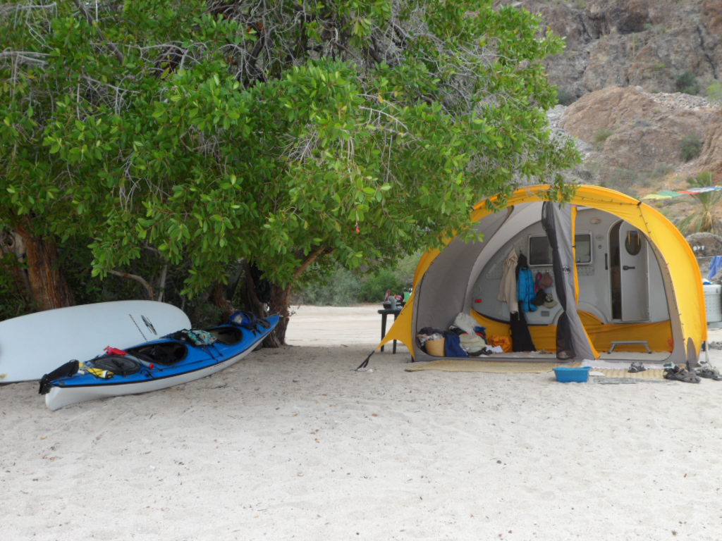
Honestly, we hadn't done much real true boondocking....oh, a night here and there - but we were talking serious life without plugging in or hooking up the hose to a water faucet. We don't have solar or a water pump...we do have a generator and good friends! (Solar is the next addition once we get home in the spring) Not everyone who travels this far (650 miles from the Arizona border) have rigs...some people actually camped in tents....motor homes are abundant as are travel trailers....

Tiny Airstream or Tiny Teardrop (behind the yellow tent room addition)


The problem of fresh water was solved by Emilio who provided us with a 55 gallon plastic barrel and delivered water as needed, along with fresh fruits and veggies every morning at 7am....if he didn't have what you wanted-just ask and he would deliver it the next day....Fresh tamales, empanadas, and tortillas could also be purchased.

Fresh Fish delivered several times a week unless you catch it yourself ....we had an abundance of shrimp and scallops in our diet....


Emilio<                Fish lady >
Other Beach Vendors.....daily visitors (to all of the beach camp grounds) made the rounds including Sundays and holidays...

Adolpho "Almost Free" trinkets
Lupe - Bread/Pastry man


Peleo - Trinkets, blankets and hand made accessories from yarn


Baskets and more..... 


Water coolers (w/sprouts) from Adolpho

The locals are extremely industrious and have created/delivery systems for the services that we "gringos" are accustomed to having...examples: the wash/waxing of your vehicles, (including the RV), delivery of pre-ordered roasted chicken and pizza, clothing and jewelry; to name just a few.

We really didn't need to drive into Mulege (approx. 22 miles) for goods unless we wanted too....or you needed fresh RO water, propane, laundry or needed to make a call.

Cell phone coverage started about 15 miles from our beach, ....and unless you were prepared with a satellite dish - no TV. Several businesses in/near town did have free WiFi - but we quickly aligned ourselves with few of the interruptions that I take for granted most days.


Sunset - same spot as sunrise....ahhh, the best in life


 PART TRES - Baja Adventure continues with activities...
~Ciao

Sunday, January 29, 2012

Baja Adventure - PART UNO our journey there...

We recently ventured down the Baja peninsula for a short visit along with friends that spend the winter there...highly recommend a group caravan if one is at all hesitant.  Like everyone, we initially had concerns, especially given the negative energy the US media tends to produce, and were relieved to discover the opposite. Our friends first hand experience, plus the book:  Traveler's Guide to Camping Mexico's Baja by Mike Church were excellent resources.


We now know why one must have Mexican vehicle insurance...the roads are, for the most part, narrow with no shoulders, and much of it is under construction.  The fog line denotes the roads edge and the drop can be 8" to 18" .... so driving requires your full attention. New sections are being completed and work is performed 7 days a week.  The MEX Hwy 1 is 2 lanes, each 9 feet wide. The newer sections of highway now have wider shoulders, but these are generally around the larger communities like Encinada or Loreto.


This short video is just a sample of some of the hazards we survived....while there are "No Passing" signs where to do so would be akin to suicide - drivers pretty much ignore those and pass you on hills and blind corners. Oh, and left turn signals - we use them to indicate our desire to actually turn left - Mexican drivers use them to signal "all clear for you to pass" so a left turn typically is done from the left lane provided no on-coming vehicles occupy it.
Pemex - state owned gas
The good news: state owned gas stations = same price per liter at every station. And you do want to fill up when you find one...sometimes they run out. (Note: not all have diesel...but Churches book does provide that info)

We stayed in the recommended RV parks, on our way down and back which gave us an added level of security. First night in  Mexico was in San Quintin - El Pabellon's RV Park - access right on the beach - gorgeous!
Pacific Ocean


Second night, just across the border between Baja Norte and Baja Sur in Guerrero_Negro - Mario's RV Park. Had the best seafood chowder in their palapa restaurant!


We arrived at our destination of Playa El Coyote - Bahia Conception on the Sea of Cortez - selected our spot on the beach for the duration of our stay and settled in.

Playa El Coyote
 Just one in a series of beaches with available sites for tents/trailers/motor homes.

Playa Los Coco's

 Not once in the six weeks we spent in living and touring Baja did we feel threatened - we arrived with an open attitude (thanks to our friends pre-briefing) and left with a high regard to the hard-working individuals that we encountered....struggling to make ends meet who were kind, polite and happy.

Even the military posts....manned mostly by 18 y/o that looked 12....polite, inquisitive. eager to learn more English in some cases, and doing their jobs....some less enthusiastically then others but hey....it's a job.


Next PART DOS: Life on the beach.....

Ciao~