Showing posts with label camping. Show all posts

Saturday, December 19, 2015

Road tripping to Angels Camp


Soooo, we left our Oregon home 30+ days ago to road-trip our way to Arizona, where we will spend ‘winter 2015’ kayaking the Colorado and other to-be-determined outdoor adventures.

As expected, we took a side road-trip on our road-trip south. Heading out from a stop in Tracy to see family, we drove east and parked our rig on the shores of Modesto Reservoir. Not only is it beautiful but visiting Canadian geese welcomed us. This county park is massive, with lots of RV hook-ups, boat launch, separate tent camping area, swimming, archery and fishing. The surrounding area is awash in groves of trees…almonds or some other variety of nuts. Regardless, it is quiet, beautiful and only 8 rigs were staying here, it is off the beaten path, but we like to be out of the noise and bustle - even small towns can be noisy if a train rumbles through.
We headed out to Angels Camp, approximately 90 miles on the back roads of Stanislaus and Calaveras counties.

Not 20 minutes later we were in the small town of La Grange, which is French for "the barn" or "the farm" and was primarily a farming community until someone found gold.


The historic La Grange Saloon replaced in 1897 after a fire burned the adjacent hotel was re-built for $13,000. Miners and river dam workers purchased the 86,670 shots of whiskey, at $.15/shot; helping the owner pay off the debt in just one year.


Another small town on the back road is Coulterville, another historic landmark, and one of those small towns that comes alive in the summer as travelers make their way to Yosemite Park.

Wood burning railcar outside the museum.

Coulterville was a mining community in the late 1890's

Magnolia Saloon Californias Oldest Operating Saloon

Jamestown National Hotel 

[In case you can't read this door sign "Hotel Registration in the SALOON"]


Wild game jerky is all the rage in Jamestown...


One of our destinations to Angel's Camp was to follow Mark Twain's footsteps. He got his inspiration for  "The Celebrated Jumping Frog of Calaveras County" (1865) during a period when he was camping with friends in the Angel Camp area, where off Jackass Hill a replica, with the original chimney and fireplace, of his cabin has been installed there. Jackass Hill is so named for the animals, were used to carry supplies to gold miners.


See you soon on the back roads of America.
~Ciao


.

Friday, September 26, 2014

It's deep, it's BLUE


 We just returned from a week-long visit to Crater Lake National Park. Descriptive words, such as awesome, beautiful, gorgeous, magnificent, spiritual come to mind - but those words just do not do justice to the spectacular vision Crater Lake is...


It was quiet. Peaceful. Restful. AND mosquito free. Yes, we had been warned. We were DEET prepared...didn't see bug one the whole week. September is the month to go if you want to be relatively kid-free as well. We live next door to six (6), yes that's right- 6, children who are for the most part -- great kids (aka, not obnoxiously noisy). So when we pulled in and were about to select a site, I glanced across the road and there were not 1, not 2, but 3 child sized bikes and a bus that had been graffiti'd in ways that only the stoners of the 60's would truly appreciate...I recoiled and said, ah, NO. My week in God's country was for rest, relax, and to rejuvenate...not to listen to small people having non-quiet moments.

So, if you are a camper, RVer or tenter...Crater Lake is for you. The spaces are large and there are some with electricity and are of different sizes so large rigs are few and far between.  If you are not one of the above, the Crater Lake Lodge is available as well. However, reservations are difficult to come by unless you book almost one whole year (10 - 12 months) in advance.  There is a NP campground for tents only that is very reasonable...$10/night. We were near the other motel, a 'motor inn', however I have not a clue as to the nightly rate.
Crater Lake Lodge

our site
Trolley tour 
Park Administration Building

Tickets for Wizard Island tours are available until mid-September, as we discovered too late to get one so as to visit it, but the boat did take us close. Two different kinds of WI tickets...a 3 hour romp or the all day (6 hours) version...only 6 a day of those are sold. So plan according. You can hike to the top, bird watch, sunbath or fish. No boats are allowed on the lake other than the tour company. And you don't need a license to fish either...they encourage fishing and lots of it. 

Wizard Island
As our tour boat captain stated...it is 1.1 miles down to the boat ramp. It's 11 miles back up. Be prepared to walk. stop. walk. stop. drink water. walk. stop. repeat often on the way back up.
Vidae Falls
Short, easy hike to Vidae Falls...you actually don't even need to get out of the car to see this from the car. It's not this view, but you can see it.


Phantom Ship
The Phantom Ship can be seen, close up, from the boat tour as they take you right up to it and stop.
Inside Watchman Tower 
Watchman Tower


The Watchman Tower hike was around 2.5 miles rd/trip and although much of it is switch backs it is also steep. And totally worth the view once you get there...this is simply breathtaking on a clear day.
Panoramic from Watchman Tower to the North/NW
We did see some wildlife during our stay...mostly birds and ground squirrels. On our last whole day we did happen to see a deer not far from our campsite. And it was posted for bears, however we saw no evidence that they were in the area. (They are faster than I so I pay attention to my surroundings. Nope, not one spotted.)

No TV, radio or internet. Well, you could buy wifi at the convenience store near the entrance or at the lodge. We were able to call out and get messages when up on the rim...actually that was just fine with us. There was a time, not so very long ago when you had to stand outside in one of these to make calls anywhere.
It's called a 'phone booth'...ancient history now. Although we did see a smaller version of this at the convenience store/gas station.

~Ciao

Saturday, November 2, 2013

Outrunning bad weather, we ended up here

We fled Oklahoma like insects fleeing pesticides. Seriously, we were in Woodward, OK on Monday and it was becoming the focal point for the "major thunderstorm" moving up through the Heartland...so we did our best imitation of Canadian geese and drove like the wind south, down Hwy 34. We just didn't want to be caught in the thunder/wind/lightning/hail spectacular that arrived, apparently on Wednesday last week.

Destination: Copper Breaks State Park, outside Quanah, TX

So, as with NE and KS, we caught the narrowest 2 lane road available and drove through some pretty amazing small towns. Small like Sharon, so small I apparently did not see it as we drove through it, (pop.138*) and Vici, (pop. 699*, the Vici City Hall - circa 1939)


and Carmargo (pop. 178* )


Many of these towns are a mere 20+ miles or so between one another and are surrounded by cattle and farming ranches.
Elk City (pop. 11700*) intersects the old Route 66

Continuing down Hwy 34 to Mangum, a stopping point on one of the cattle- drive trails from Texas through OK to Abilene, KS. The photo below depicts cattle-drive life and is titled 'Up the Trail'.
 Mangum is a good sized town...(pop. approx. 3100*  and Margaret Avery, nominated for her role in The Color Purple was born here.) The mural below was on a business we passed leaving town.

We stopped in Carter (pop. 256*) for lunch....next to the town's cotton gin (which is now someone's residence) and the cotton co-op, where the photo below displays a bale of cotton and the reflection of our rig.)


We left Hwy 34 - at it's end and got onto Hwy 6 near Eldorado (pop. 446*), for the last 20 miles of Oklahoma and crossed over near the town of Quanah. Hello! Texas!

Roughly 20 miles inside the border is Copper Breaks...a lovely, quiet state park with electric/water sites, separate dry camping sites available and a equestrian area...after all it is Texas.

We were greeted by this rather impressive example of a Texas longhorn...our first sighting. I had to wonder about the stability of that rather flimsy looking fence...but so far, as of Monday when we arrived, it is the only day we have seen the herd.

The park office has a museum on site and offers a nice selection of artifacts and local area information. When available they sell "Stink Bait" - and yes I had to ask....it's a gop of goo that smells. Apparently the fish "adore" it.
This restored 'chuck wagon' is featured, as is quite a bit of the local Comanche history, given Quanah Parker was the last Chief and the town's namesake. His mother, Cynthia Ann Parker, at age 6, was kidnapped by the Comanche's, raised as one of their own and married within the tribe. My next post will be on Quanah...both the town and the Native American.

This is Big Pond, which when the water level is higher, feeds Lake Copper Breaks. Currently, due to the 3 year drought, water restrictions are in place for Quanah, Crowell and the surrounding areas.

Each camping site has a tepee shelter, with table and lantern hook. This one is closed as it appears Thor got mad and sent down a lightning bolt at some point in the not too distant past.

We are not using ours...for it is inhabited by a family of bats - really, just rodents with wings (eeuuuwww) and a village of wasp nests. So we are being good neighbors and giving them a respectful space in which to enjoy their living quarters.


I must say the night sky here is...in a word - AMAZING! No business/street/housing lights = dark, very dark night skies. We were able to photograph Venus 2 nights ago...also, the Milky Way is so close I feel as though I could reach out and touch it.

Next up....Quanah. In the meantime, thank you for reading my post...I hope you enjoy our travels as much as we do.

~ Ciao

NOTE: * denotes population number during 2010 US census.


Tuesday, October 22, 2013

Bits and pieces as we race towards the SUN

We are traveling east and will be turning out of Wyoming and going south soon. It is just plain cold, too cold to hang out in beautiful WY or NE...but we have been tempted. WY -, specifically Laramie and Cheyenne, we will return when it's a bit warmer to explore.

For those of you who read last week's post...here is a very short video Mike took of the Perrine Bridge (Twin Falls) Base Jumper....ENJOY!


Traveling into different states is really educational, fun, and thought provoking...I'm starting to pay attention to the differences...it's a cultural shift that rarely happens at home and once we get back into our winter-routine I find it again. One of those for me is discovering all the different fast-food joints that I will never, ever in a million years enter, let alone buy anything to eat from them. (Yes, I am a fast-food snob, but that is a entirely different blog and longer post, with a different audience.)

It's Chester Fried...found at a truck stop in Utah...do they serve it in buckets? I now wish I had gone inside to see if Colonel Sanders was wearing a cowboy hat and was clean-shaven.

 
Our overnight in Honeyville, at the Crystal Hot Springs, had a herd of sheep out our back window and....


a duck couple, laying eggs and being fed Jelly beans by the 2 small girls, next door to us. That's an egg just above the duck on the left....the next morning there were two eggs. The couple were resting comfortably when we left...both ignoring said eggs.


We left Utah for Wyoming...big, big mistake on our part we soon discovered. Wyoming is at a higher altitude, well not at the start, but by the time we reached Rock Springs, elevation 6388' we hadn't drank nearly enough water and having only just leaving sea level...we both were suffering from headaches and that tiredness that altitude brings on.
The mistake? Higher elevation = colder temperatures and did you know the wind blows at really high rates of speed here?

We found parking at the Sweetwater Fairgrounds (Sweetwater Fairgrounds)
via All Wyoming Campgrounds... the fairgrounds has 1200 parking sites! We 'guessed' closer to 500....this place is massive. Since it was just us and another trailer it was very quiet, even for a Friday night. Don't let the Sun fool you...it got really "crispy" come dark...so crispy that Mike unhooked us from the water line...."crisp" as in frigid/freezing. We were both really happy to be here for just one night. (I just wished that had been the end of the 'crisp air' story.)


Next on the trip menu... giddy-up Cheyenne WY. Little did we know that high winds AND more altitude was in our future. And according to the weather reports, some snow had dropped in on Cheyenne earlier in the week, but "not to worry, it was forecast to rain by Sunday". Yep, erm, right...not happening during our 2 day visit.


The highest point on I-80 is located at 8640" just outside Laramie, WY, and yes the wind was blowing where these photos were taken last Friday. The wind blew so hard and was so loud, we both donned ear plugs just to hear the radio.


Above...the remains of the snowfall days earlier.

Eight days out, 1550 miles through OR/ID/UT/WY and we are only half-way to our "we-can-start-to-relax" state of Louisiana. I know, we probably ought get to the 'start-to-relax' part now....it's just been too d**n cold up here in the northern hemisphere of the US.

While in Cheyenne we drove down to Ft Collins to meet up with friends we met while visiting Lake Louise 2 years ago, who drove up from Denver for lunch...so if you are visiting Ft Collins, treat yourself and dine at  Austin's American Grill  - the food was delicious, the company was marvelous. Thanks H & M!

If you are cruising I-25 to Ft. Collins, look for the bison up in the hills, you can see it for miles.


OK, I'll admit it....I am a West Coast woman...I have never seen signs announcing road closures at on-ramps - followed by gates that actually close the ramp...


this just boggles my mind....
 
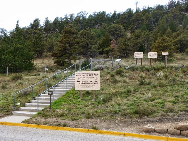
Just as we are about to leave WY...Pine Bluffs rest area, right at the very edge of the state. High-Plains-Archaeology-Museum and a visitors center is conveniently located, more-like disguised, on the grounds of the rest area. The volunteer was kind enough to tell us a bit about the museum, open June - Aug... built on ground where Native American artifacts had been discovered.


and if you are a Cabelas fan, the photo below is their distribution center and store in Sidney, NE...left to right all Cabelas...it's gigantic.


and we witnessed another circle of life....like us, birds heading south.


We head towards Oklahoma over the next few days.
~Ciao